Matterhorn Guide
A visitor's guide to seeing, photographing and understanding the Matterhorn — the Horu — without ever roping up: viewpoints, light, history and the small practicalities of the most famous mountain in the Alps.

Photo: Sam Ferrara / Unsplash
- ✓The Matterhorn — Horu in the old Walliser tongue, Cervino on the Italian side — stands 4,478 m above a car-free village at 1,608 m.
- ✓Its near-perfect pyramid is a geological accident: four faces carved by glaciers, each pointing close to a compass direction.
- ✓First climbed on 14 July 1865 by Edward Whymper's party — a triumph that turned to tragedy on the descent.
- ✓You do not have to climb it to feel it. The whole of Zermatt is arranged to look at it, and the best views are reached by cog, cable car and footpath.
The mountain that made the village
Some mountains hide. The Matterhorn announces itself. Walk out of Zermatt's station, look south down the Bahnhofstrasse, and there it is at the head of the valley — a lone, leaning pyramid of rock that seems too deliberate to be natural, as if a child had drawn the idea of a mountain and the Alps had agreed to build it. The Walliser call it the Horu. Italians on the far side call it Cervino. To the rest of the world it is simply the Matterhorn, the most photographed peak on earth and the reason a small, car-free village at 1,608 m became one of the great names in mountaineering.
It rises to 4,478 m, which makes it tall but not the tallest thing in sight — the Dufourspitze on Monte Rosa is higher, and from Gornergrat you can count more than two dozen four-thousanders. What sets the Horu apart is its isolation and its shape. It stands alone, unbuttressed by neighbours, so the eye has nothing to measure it against except sky. That solitude is why it dominates every photograph and every dinner-table view in Zermatt, and why this guide is less about the summit than about the dozen quiet places the village gives you to simply look at it.
Why it looks the way it looks
The Matterhorn's improbable symmetry is not design but erosion. Geologically it is a horn — a peak carved on four sides at once by separate glaciers grinding back into the same block of rock until only the central spire was left. Its four faces look out roughly north, south, east and west, which is why it photographs as a clean pyramid from so many angles rather than the messy ridgeline most big peaks present.
Stranger still, the rock at the very top did not start here. The summit belongs to the African tectonic plate, thrust over the European one when the two continents collided to raise the Alps; the lower mountain is European basement rock. You are, in a real sense, looking at a piece of Africa balanced on Europe. None of this is necessary to enjoy the view, but it is the kind of fact that makes a still morning at Riffelsee feel a little more astonishing.

1865: triumph and tragedy
For years the Matterhorn was thought unclimbable, and the race to the top was a quiet obsession of the golden age of alpinism. On 14 July 1865 the Englishman Edward Whymper finally reached the summit by the Hörnli ridge with a party of seven, beating an Italian team climbing from the other side. The victory lasted only as far as the descent. A slip on the upper rock pulled four of the seven to their deaths down the north face: Douglas Hadow, the Reverend Charles Hudson, Lord Francis Douglas and the guide Michel Croz. The rope between the survivors and the fallen broke.
The disaster made the mountain world-famous overnight and gave Zermatt its sombre undercurrent. You can read the whole story in stone at the mountaineers' cemetery and in the Matterhorn Museum, where the broken rope is kept. It is worth an hour. The Horu is beautiful, but it has never been gentle, and the village has never pretended otherwise — well over 500 climbers are estimated to have died on it since that first ascent, one of the highest tolls of any Alpine peak.
Where to see it — by altitude, not address
Zermatt is a place you read by height, and the Matterhorn rewards you for gaining some. From the village floor the view is iconic but distant; ride a lift and the peak fills the frame. The three classic high vantages each show a different face and mood.
Gornergrat (3,089 m), reached by the cog railway, sets the Horu among a panorama of glaciers and four-thousanders — the grand, encyclopaedic view. Matterhorn Glacier Paradise (3,883 m), the highest cable-car station in Europe, puts you almost level with the summit on its southern flank, close enough to feel the cold coming off the ice. And Riffelsee, a short walk below Gornergrat at Rotenboden, gives the postcard: the whole pyramid mirrored in a small alpine tarn on a windless morning.
- Gornergrat (3,089 m) — the panoramic view, the Horu among 29 four-thousanders. Sit on the right going up.
- Matterhorn Glacier Paradise (3,883 m) — almost level with the summit, the closest you'll stand without climbing.
- Riffelsee (Rotenboden, ~2,757 m) — the reflection. Still water, early light, anticlockwise around the pool.
- Sunnegga & the Five Lakes — Stellisee mirrors the peak too, with an easier, flowery walk to reach it.
- The Bahnhofstrasse — don't underrate the village-floor view down the main street at dusk.
 Gornergrat guideThe cog railway to the highest open-air station in Europe and its Matterhorn panorama.
 Matterhorn Glacier ParadiseEurope's highest cable-car station at 3,883 m, almost level with the summit.
 All Matterhorn viewpointsThe full hub — every angle on the Horu, read by altitude and the lifts that reach it.
Light: the pink summit and the long shadow
If you do one thing in Zermatt, watch the Matterhorn at first light. For a few minutes before the valley wakes, the rising sun catches the east face and the summit glows a deep rose-pink while the village below is still in cold shadow. The Swiss call it Alpenglühen, and on the Horu it is unforgettable — the cleaner the air after a cold night, the more vivid the colour. You don't need a lift; any east-facing window or the bridges over the Vispa will do, and the show is free.
Sunset works the other way, lighting the peak from the side and throwing a long triangular shadow across the sky to the east. For the pink dawn, point yourself at the mountain early and dress for the cold; for the photographer's golden hour, the higher viewpoints hold the light longest. Either way, build the trip around a clear forecast and keep your headline view flexible — a single bright morning is worth re-arranging a whole day for.
Photographing the Horu
The Matterhorn is generous to photographers and unforgiving of haste. The two ingredients that matter most are stillness and timing: still air for reflections at Riffelsee or Stellisee, and the soft directional light of the first and last hour. A midday shot under flat sun is the one that looks like everyone else's; an early, low-angle frame is the one that looks like yours.
Carry a lens with some reach as well as a wide angle — the peak is further away than it feels, and a tighter crop of the summit ridge against blue sky can be stronger than the full panorama. Watch the cloud, too: a banner of vapour streaming off the leeward side is a sign of high wind aloft and makes for a dramatic, living portrait of the mountain rather than a static one.
- Best light: the first hour after sunrise and the last before sunset. Avoid flat midday glare.
- Reflections need dead-calm air — go at dawn before the valley breeze picks up.
- Bring reach as well as width; the summit is further than it looks from the village.
- A cloud banner off the leeward face means strong wind aloft — dramatic, and a weather warning.

Standing closer: hikes and the Hörnli hut
You can get genuinely close to the mountain without climbing it. The Matterhorn Glacier Trail and the well-trodden path up towards the Hörnlihütte (3,260 m) — the historic base camp at the foot of the climbers' ridge — let walkers feel the scale of the thing from below, surrounded by moraine and the constant trickle of meltwater. The Hörnli hut is reached on foot from the Schwarzsee lift station; it is a serious mountain walk, not a stroll, and the upper sections demand sure feet and good weather.
For most visitors the right amount of closeness is a terrace lunch with the peak filling the view — at Findeln, at Riffelalp, or on the Gornergrat. The Horu is a mountain best admired with a long lunch and a clear head, and Zermatt is built to let you do exactly that.

Matterhorn Viewpoints in Zermatt
Every angle on the Horu — Gornergrat, Riffelsee, Glacier Paradise, Rothorn and Stellisee, plus the best village views — read by altitude and reached by lift and cog.
Read guide
Matterhorn Sunrise & Sunset
Where and when to catch the Matterhorn at first light, the pink alpenglow and the evening blue hour — the best vantages in and above the village, the timing, and the trick of catching the peak before the valley does.
Read guide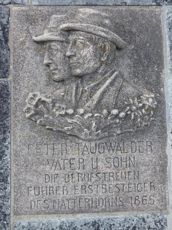
Mountaineers' Cemetery
A respectful guide to the graves of climbers who died on the Matterhorn and the high peaks around Zermatt — the human cost behind the postcard, beside the village church.
Read guideMore in Matterhorn Views
6
Blauherd & Stellisee Guide
The Sunnegga-side reflection lake and the lift station that reaches it — how Blauherd and Stellisee fit together, the short walk down, the dawn timing and the Five Lakes routing that makes the picture.
Read guide
Glacier Palace Guide
What to expect inside the ice cave carved beneath Matterhorn Glacier Paradise — ice sculptures, the slide, the cold, and how to plan time at 3,820 m without rushing.
Read guideGornergrat Guide
The cog railway, the viewpoints, Riffelsee, the Kulmhotel, the mountain restaurants and the weather strategy for the highest open-air railway station in Europe.
Read guide
Gornergrat vs Glacier Paradise
A decision guide to Zermatt's two headline high viewpoints — Gornergrat by cog railway and Matterhorn Glacier Paradise by cable car. How they differ on view, altitude, weather risk, time and who each one suits.
Read guide
Klein Matterhorn Guide
What Klein Matterhorn means for visitors — the 3,883 m summit station, how it relates to Matterhorn Glacier Paradise and the Italian crossing, and handling the thin air.
Read guideMatterhorn Glacier Paradise Guide
Tickets, the cable-car route, altitude, the Glacier Palace, the viewing platform and weather advice for Matterhorn Glacier Paradise on Klein Matterhorn — the highest cable-car station in Europe.
Read guide